Hailstorms present a significant and often underestimated risk to properties across Canada, with the potential to cause extensive damage to residential, commercial, and agricultural assets. As climate patterns shift and severe weather events become more frequent, the insurance industry must adapt to the evolving hail risk landscape. By leveraging high-quality hail data, insurers can better assess and manage hail risk, ensuring that their portfolios are adequately protected.
The Growing Importance of Hail Risk Assessment
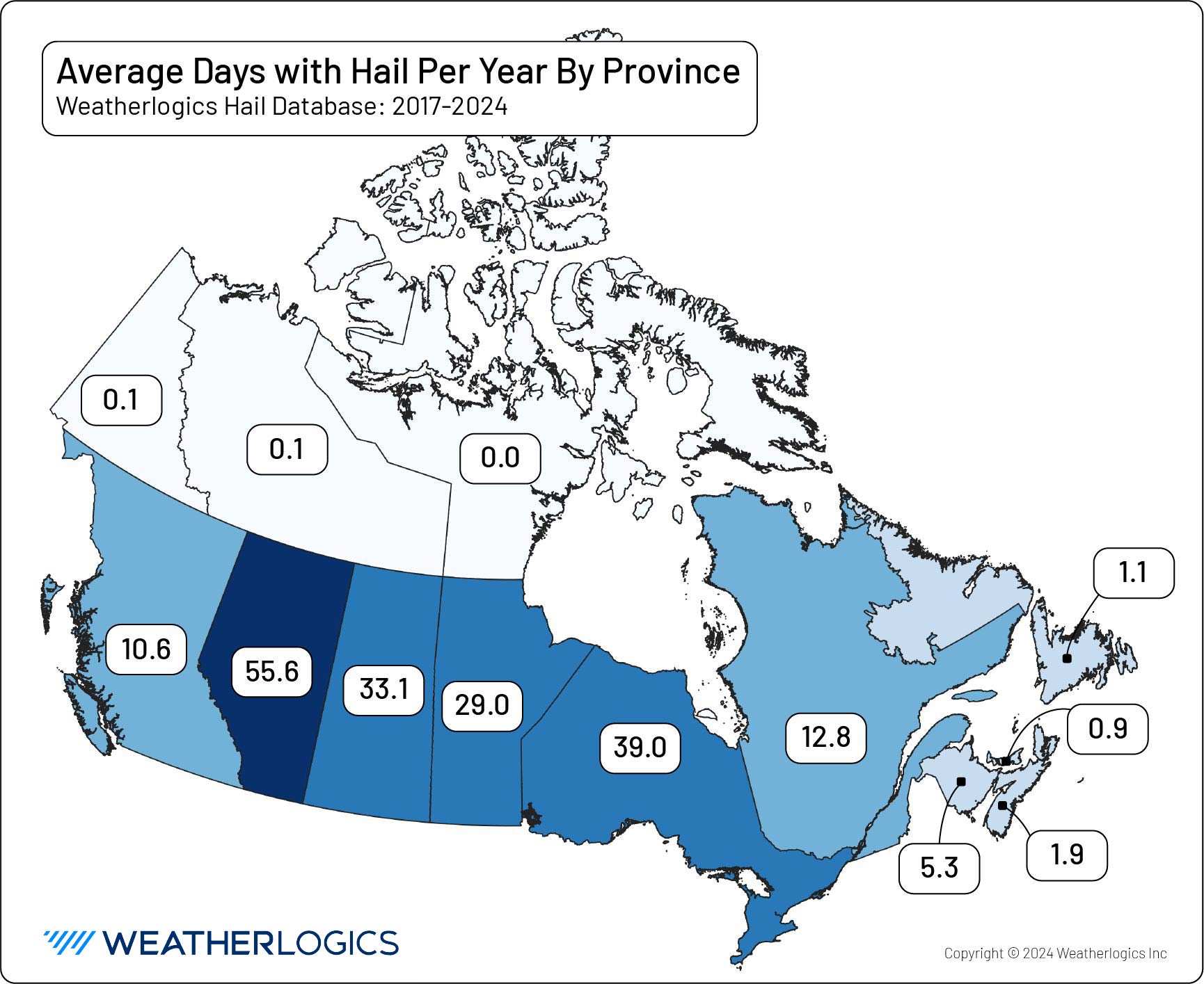
Hailstorms are a common occurrence in Canada, particularly in the Prairies and parts of Ontario, Quebec, and British Columbia. These storms can produce hailstones of varying sizes, which, when combined with high winds, can cause significant damage to roofs, vehicles, crops, and other exposed assets. The economic impact of hailstorms has been steadily increasing, making it imperative for insurers to accurately model and price hail risk. Canada’s second largest catastrophic loss was caused by hail when a single storm on August 5, 2024 caused $2.8 billion of damage in Calgary. Just 4 years earlier, in 2020, Calgary set the previous record for hail damage in Canada, with a loss of $1.3 billion. Winnipeg, MB, and parts of southern Ontario also experienced catastrophic losses recently, with both regions seeing significant hail in 2023.
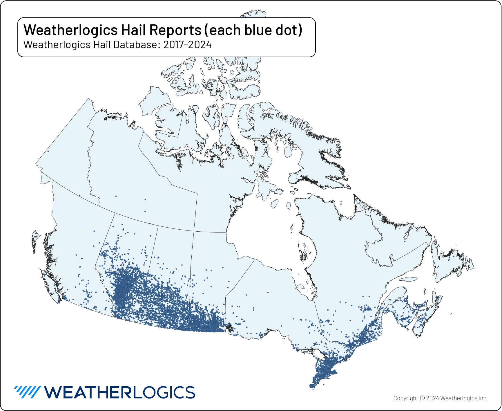
Weatherlogics has been at the forefront of hail risk assessment in Canada, developing a proprietary hail database that contains over 10,000 reports from across the country between 2017 and 2024. This extensive dataset forms the backbone of our hail risk analyses, enabling insurers to better understand the frequency, severity, and geographical distribution of hailstorms.
Catastrophe Modeling for Hail Risk
Catastrophe models are essential tools for the insurance industry, allowing underwriters and actuaries to quantify the potential financial impact of natural hazards like hailstorms. These models incorporate data on historical hail events, climatological trends, and vulnerability assessments to produce frequency/severity curves, storm footprints, and other critical metrics. However, unlike other countries like the United States and those in Europe, Canada does not have a public long-term database of hail reports. In fact, a recent hail climatology update by Etkin for the Institute of Catastrophic Loss Reduction in 2018 noted that the number of weather stations measuring hail in Canada since 2007 is “trivial.”
To fill this gap in hail data, Weatherlogics has been carefully collecting high-quality hail data, which is used to produce comprehensive hail climatologies and frequency/severity curves for major Canadian cities, offering insurers invaluable insights into the localized risk of hail damage. By analyzing historical hailstorm data, we can estimate the probability of hail events and the frequency of hailstone sizes and storm intensities.
Storm Footprints and Hail Damage Swaths
One useful tool for insurers is the storm footprint, which shows the geographical extent and intensity of hailstorms. Weatherlogics produces daily storm footprints that highlight the swaths from individual hailstorms. These footprints are crucial for post-event loss assessments, helping insurers to quickly determine the areas most affected by hail and estimate the potential claims volume.
Our storm footprints are developed using data from our proprietary hail database, combined with real-time weather observations and radar data. This allows us to produce accurate and timely assessments of hail damage, supporting insurers in their claims management processes and improving their overall risk management strategies.
Partnerships and Collaboration
Weatherlogics is proud to be partnered with leading organizations such as the Northern Hail Project, Palliser Insurance, and Coop Hail Insurance. These partnerships allow us to collaborate on research and development initiatives, share data and insights, and enhance our understanding of hail risk in Canada. Together, we are working to improve our understanding of hail risk and develop innovative solutions to mitigate the impact of hailstorms on insured assets.
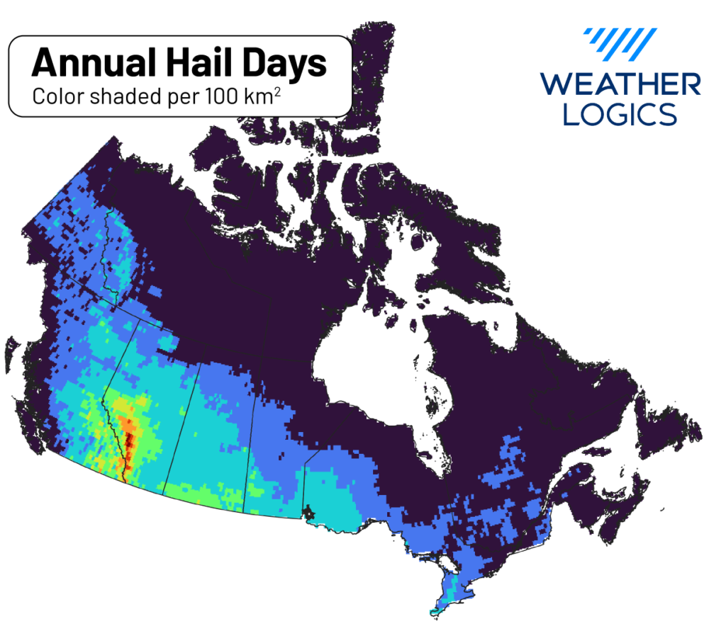
A Gridded Hail Climatology for Canada
In our ongoing efforts to advance hail risk assessment, Weatherlogics has developed a gridded hail climatology for Canada (sample above). This project created a high-resolution, spatially continuous dataset that provides detailed information on hail frequency and intensity across the country. The gridded climatology is an invaluable resource for insurers, enabling them to assess hail risk at a granular level and refine their catastrophe models accordingly.
The gridded hail climatology incorporates data from our proprietary hail database, along with inputs from other gridded data sources. It provides insurers with unprecedented insights into the spatial variability of hail risk, helping them to better understand the potential exposure in different regions and adjust their pricing and underwriting strategies accordingly.
Conclusion
As the insurance industry continues to face the challenges posed by severe weather events, accurate and reliable hail risk assessment has never been more critical. Weatherlogics, with its proprietary hail database and strategic partnerships, is uniquely positioned to support insurers in managing hail risk effectively. By leveraging our cutting-edge tools and insights, insurers can enhance their risk management strategies, improve their pricing accuracy, and ultimately protect their portfolios from the growing threat of hailstorms.
For more information on how Weatherlogics can help your organization assess and manage hail risk, please contact us today.